Sign In


Leica Nova TM50 Total Station
Product Code: Tm50
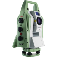
We live in a dynamic world. Buildings and dams settle, bridges flex and vibrate, rock masses shift, mud slides, glaciers flow and volcanoes erupt. Whether by human activity such as mining and construction or by natural processes such as climate change and erosion, the world in which we live is continually changing. Engineering companies and contractors face increased challenges monitoring this change. They are being charged with, and being held liable for, the condition of the structures they create and maintain. In order to surmount these challenges, engineers need to be able to measure structural movements to millimetre-level accuracy. For equipment to manage and monitor these structures, engineers rely on Leica Geosystems and the Leica Nova TM50 Monitoring Station: because every half second counts! Image assistance for every situation The Leica Nova TM50 includes an overview camera and a telescope camera with 30x magnification and autofocus. With state-of-the-art image processing technology the Leica Nova TM50 delivers the highest quality image for complete visual documentation of the monitoring environment. Obstructions in the line of sight can be easily inspected remotely, avoiding safety concerns in highrisk environments. Continuous operation and reliability The Leica Nova TM50 meets the challenge of 24 hours, 7 days a week monitoring applications. It is designed to withstand the roughest use in the most severe environments. The Leica Nova TM50 will operate throughout a wide temperature range and is protected against wind driven rain, sand and dust. The Leica Nova TM50 is fully operational in bright sunlight and complete darkness. Complete monitoring integration The Leica Nova TM50 forms one component of a unique Monitoring solution which seamlessly integrates total stations, GNSS receivers and antennas, geotechnical sensors, software and IT communication infrastructures. Leica GeoMoS software provides a highly flexible automatic deformation monitoring system that is able to combine sensors to give you peace of mind. Facilitating important decision making Leica GeoMoS software provides a highly flexible automatic deformation monitoring system that is able to combine geodetic, geotechnical and meteorological sensors to match the needs of your monitoring project, whether it is large or small, temporary or permanent. With the addition of the GeoMoS Web service, visualisation and analysis of monitoring data can be performed anywhere and anytime using a web browser, mobile phone or tablet. Make important decisions with Leica GeoMoS.The Leica Nova TM50 is the ultimate tool when it comes to fulfilling your complex monitoring and measuring requirements. With state-of-the-art image processing technology, the TM50 delivers the highest quality image for complete visual documentation of the monitoring environment, and is capable of monitoring environmental and structural movements down to millimetre accuracy. Additionally, obstructions in the line of sight can be easily inspected remotely, avoiding safety concerns in even the most high risk environment.
For more information on Leica Nova TM50 Total Station talk to Sunbelt Rentals Survey
Enquire Now
List your company on FindTheNeedle.