Sign In


n4ce Survey
Product Code: N4Ce-Survey
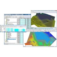
The Survey edition of n4ce is ideally suited to accompany another CAD or modelling system and provides all the survey processing needed to convert raw survey data into graphical images. These can them be plotted and exported to AutoCAD DXF, Bentley MX GENIO or other file formats. All popular instrument formats are supported including those from Leica, Trimble, Topcon and Sokkia. Survey data will appear in its own folder on the Project tree. Control data will be stored separately in its own Stations folder. During reduction or adjustments these folders will be updated automatically. CAD can be imported into its own folders and used as backcloth's to generate coordinates for setting out. A Code Table converts then your survey codes into graphical features. At the heart of n4ce is a Code Table, which converts your survey into graphical elements. Each surveyed point will be assigned a point code, like BD for building or TR for a tree. The lookup table will then translate this into a feature with its own type, style, colour, layer and if appropriate size. If you move or delete a point then anything attached to this point will be similarly affected - rippling through to the spreadsheet display if the edit is done in graphics or visa versa. We call this duality of display and edit. Comma Codes and Dimensions extend the coding and introduce attribute data which can be displayed graphically using Text Macros. Images can be attached to points. Multiple graphics screens can be shown simultaneously with editing in one screen being seen in others. A twin screen setup is highly recommended. Reports can be created from processed data. In the case of least squares network adjustment, error ellipses will give you a graphical indication of how good an adjustment has been performed, with selected weights. A backcloth facility allows you to register certain data folders with other data type, including Aerial photography. Building elevation surveys are created by flipping the Y and Z coordinate axes, after rotating about a baseline.Survey processing and adjustment with spreadsheet editor, upload and download from/to Total Stations, XYZ extract from CAD for setting out and Import/Export formats, plus Building Elevations.
For more information on n4ce Survey talk to Sunbelt Rentals Survey
Enquire Now
List your company on FindTheNeedle.